You are here: Boundaries, Rights of Way, Adverse Possession
The first thing that the law does is to remove from the land a bundle of rights. That bundle of rights provides for how the land is held, for example freehold, what rights exist over the land such as a right of way and how those rights can be "pinned" onto the land. It is this last one which exercises our minds in this paper.
Before launching into law and looking to maps the main map provider is and has been since 1791, the Ordnance Survey (OS).
Ordnance Survey mapping:
A brief history
- Started in 1791;
- From 1801 Os produced small scale mapping using the Cassini projection in England and Wales and the Bonne projection in Scotland;
- In 1840 large and medium scale plans were published in Great Britain;
- The Survey Act of 1841 requires OS to „mere administrative boundaries to detail on their maps.‟
- In 1945 the first large scale (1:1250 and 1:2500) National Grid maps were published;
- In 1973 the first „digital maps‟ were produced;
- Superplan first appeared in 1992;
Ordnance Survey Map Accuracy
The accuracy of any map is determined by the accuracy of both survey and plotting.
Ordnance Survey maps are made by graphic detail survey which uses the principle that the alignment on the ground is replicated by the alignment on the map. Thus, a straight line from one fence corner to a building corner is shown in the same way on the map. Any deviation from the straight line is ignored when that deviation is less than a „line width‟. The OS used an 8-gauge line, which, at 1:2500 is 0.2 mms thick and represents 0.50 metres on the ground. The surveyor has to plot physically the measurement, made to the nearest ± 40 cms, onto the map. Consequently, any deviation from the straight line which is less than about 0.5 metres is ignored. The accuracy also reflects the type of feature measured to; it is easier to determine the face or middle of a brick wall than to define the middle of the root line of a hundred year old hedge or edge of a bank.
Various editions of OS 1:2500 scale map are of differing, yet homogeneous accuracy. In OS mapping there was never any consideration of legal boundaries with the sole exception of the relationship of private boundaries with administrative boundaries and as no administrative boundaries abut the plots in this case it is sufficient to say that the boundary features shown on the OS map are topographical features only.
In respect of map accuracy the statement by Harley that 1:2500 scale maps have a Root Mean square error of ± 2.0 m is authoritative. For the sake of completeness the table below shows the accuracy of all OS large scale mapping.
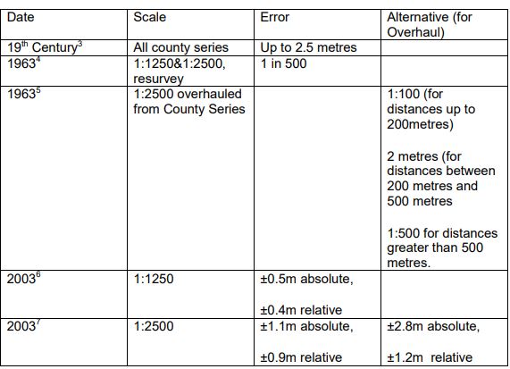
2 Harley J B, 1975, Ordnance Survey Maps a descriptive manual, OS, Southampton, p164
3 Oliver, R, 1993, Ordnance Survey Maps - a concise guide for historians, The Charles Close Society, London
4 ibid.
5 ibid.
6 http://www.ordnancesurvey.co.uk/
7 http://www.ordnancesurvey.co.uk/
The other point to be made, besides that of precision, is that not all features are shown. If any feature is within 0.5m at 1:1250 or 1m at 1:2500 scale of another feature then the more prominent feature will be shown.
OS Mapping
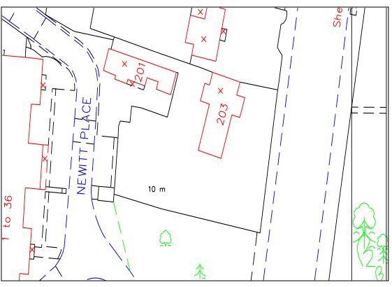
The map below is a Superplan from OS. It is digital data which can be plotted at any scale. The problem of course is that any errors are also scaled up. One further fact is that the lines remain a constant width which leads to a supposition that distances can be measured to millimetres. Of course using software such as AutoCADtm distances can be determined to great precision but the accuracy remains the same at 400 millimetres for 1:1250 basic scale (urban areas) and 1 metre for 1:2500 basic scale (rural) at best.
The Land Registry
The Land Registration Act 1925 has been superseded by the Land Registration Act 2002 (LRA2002) with the accompanying Land Registration Rules 2003 (LRR2003).
The main thrust of LRA2002 is to continue to keep a register of tile and to enable rules to define:
- The information to be included in the register;
- The form in which that information is to be held;
- The arrangement of the information.
The register contains:
- A proprietorship register (who owns the rights in the registered land);
- A property register (what is registered);
- A charges register (who has rights over the land, such as a mortgagor);
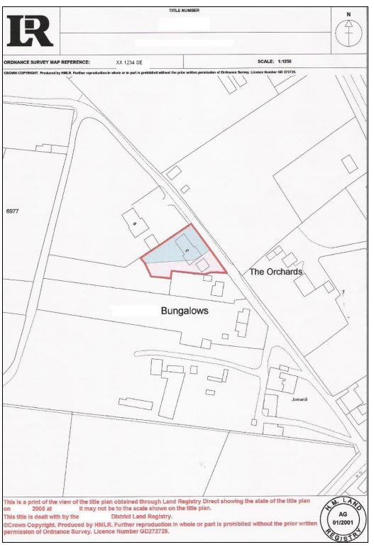
- A Title plan (an OS map on which the registered land and rights can be seen).
There is an index map showing which land is registered and the colours used in all of these plans are standard. For further details the Land Registry‟s website www.landregistry.gov.uk provides comprehensive help for lawyer, surveyor and property owner.
The plan below is an example of a Title Plan.
General boundaries
In English law, general boundaries are the rule, in both the Land Registration Act 2002 (LRA 2002) and its precursor LRA 19258. The portrayal of a bounding feature on the HMLR Filed Plan is accordingly:
"(1) The boundary of a registered estate is shown for the purposes of the register is a general boundary, unless shown as determined under this section.
(2) A general boundary does not determine the exact line of the boundary"
"... the exact line of the boundary will be left undetermined – as, for instance, whether it includes a hedge, fence or ditch, or runs along the centre of a wall or fence, or its inner or outer face, or how far it runs within or beyond it; or whether or not the land registered includes the whole or any portion of an adjoining road or
stream."
In other words the HMLR Filed plan is indicative only of the exact line of the boundary. The legal boundary is a line of no thickness and so can be contained within or about any physical feature.
This is problematic in that Land Registry use Ordnance Survey maps which themselves have a limiting accuracy, surveyed as they are to a scale of 1:1250 in urban areas. This means that the Filed Plan needs to be considered geometrically and in the context of ground features extant at the time of survey.
The Expert Witnesses’ task
Guiding points of law
There are four points which I believe are worth making. The first is that, according to Sara10 there is sufficient authority for the parcels clause to be construed together with the conveyance plan and not each in isolation. In Wiggington & Milner v Winster Engineering11 Buckley LJ stated that the court must „... have a regard to the conveyance as a whole‟.
10 Sara, Colin, 2002, Boundaries and Easements, Sweet & Maxwell, London, p9
11 [1978]1 WLR 1462, [1978]3 All ER 436
I make this comment because it is often difficult to reconcile the words with the plan.
The second point is that of Cumming-Bruce LJ in Scarfe v Adams [1981] 1 All ER 843; where at page 847 he said:
"And the starting point is that extrinsic evidence is not admissible as an aid to its construction [that is of the transfer] unless the relevant provisions of the deed are uncertain, contradictory or ambiguous."
In other words, the deeds must suffice unless it can be shown that there are real problems in defining the land or the rights in the land.
The third point is per the boundary dispute Jacob LJ in Horn & Horn v Phillips and Phillips [2003] EWCA Civ 1877 where at 15 he states:
"I would only add this, it does not follow that the Phillips are necessarily adjacent to the Horns over the boundary. Whether they got the land up to the boundary depends upon their conveyance, not upon this."
The point here is that the boundary of each property is defined by the deeds for each property, and not by deeds from another property. Therefore, the boundary of one property is not, on the face of it, dependant on any others‟ title(s).
The fourth point is from Pill LJ in Kupfer & Kupfer v Dunne [2003] EWCA Civ. 1549 at 14: -
"In Alan Wibberley Building Limited v Insley [1998] 1 WLR 893, Lord Hoffmann, having referred to Land Registry maps based upon the Ordnance Survey, added that “the precise boundary must, if the question arises, be established by topographical and other evidence”. Lord Hoffmann had specifically in mind natural features such as hedges, but the same principle in my view applies when considering the line of a boundary between residential premises on which features have been removed, modified and added over the many years the premises have been occupied. In the millions of such situations which exist around the country, there will very frequently have been changes such as those which occurred in this case, a wall replacing a fence and a fence replacing another, as a result of which small deviations in the boundary will occur once the limitation period has expired. There may well be other cases where an original straight line may remain the boundary notwithstanding periodic alterations. It would depend on the evidence. In the present case it is not disputed that the 1980 fence correctly delineated the boundary, at any rate once twelve years had elapsed. The dispute is as to where that fence was positioned. Fortunately, in the overwhelming majority of cases, consultation, discussion and agreement will avoid the appalling situation which has arisen in this case, the expenditure of very considerable amounts of money in a dispute over a very inconsiderable area of land."
This point brings out the matter of general boundaries and that the physical features marking the boundary change over time and which the legal boundary may follow depending on the facts of the matter.
The surveyor’s task
The surveyor may well decide to make a survey of the land. In so doing he (or she) must consider what needs to be surveyed and to what accuracy. Sometimes the requirement is to determine gaps between houses to the nearest millimetre: fool ‟s errands in most instances as the surfaces to be measured between often vary by more than 5 millimetres. Generally most land survey methods, using calibrated equipment, produce measurements which are both precise and accurate to ± 10mms.
Adverse Possession.
Adverse possession relates to a parcel of land and therefore that parcel of land needs to be defined on the ground. Regardless of the general boundary rule there are various aspects to adverse possession: the first is to define it and consider how that definition is honed by case law; the second is how the Land Registry deals with adverse possession. In Steven Fellows v Network Rail Infrastructure Ltd12 Longmore LJ commented on Her Honour Judge Hallon‟s judgement as being a correct statement of the law as:-
6. The judge set out the law in a way which is not controversial. She said there were four matters for a claimant seeking to substantiate his claim to a possessory title to satisfy as follows:
"The first of those is that either there has been discontinuance of possession by the paper owner or a dispossession of the paper owner by the person claiming title. Secondly, that the person claiming has taken actual possession of the land with a sufficient degree of exclusive physical control. Thirdly, that he has the intention to possess in his own name, on his own behalf to the exclusion of everyone else, including the paper owner. Fourthly, that since the time of either dispossession or discontinuance the person taking possession has had actual possession with the intention to possess continuously for a period of not less than 12 years running up to the time when the paper owner of the land reasserts their title."
12 [2004] EWCA Civ 1228
Ownership of an estate land is conferred by title usually by deed of conveyance or transfer. This 'paper title' gives the owner the right to possess the land with or without restrictions which are usually included with in the deed. However, there are various cases13 where the Courts have held that possession of land is as, if not more important than title to it. For if someone is in possession then anyone with a claim to that land has to prove that he has a better title than the possessor. In short, possession is nine tenths of the law.
'Discontinuance' is „the abandonment of possession by some person, followed by the actual possession by another person.'14 Subsequent cases15 have endorsed that view and added that; 'discontinuance of possession by the true owner itself is neither here nor there unless accompanied or followed by adverse possession by another party.'16
13 Hunter v Canary Wharf Ltd [1997] AC655 , Minister of State for the Army v Dalziel [1943] 68 CLR 261
14 per Blackburne CJ in McDonnell v McKinty [1847] 10 ILR 514 526
15 Hounslow London Borough Council v Minchinton [1997] 74P & CR 221
16 as above at 232.
Thus, it is not enough for someone to walk away from their land – someone else needs to take occupation of it. What constitutes occupation or possession is described further on.
In the landmark case of J A Pye (Oxford) Ltd v Graham17 Lord Browne – Wilkinson explained that the relevant question was whether the Grahams were in possession of the disputed land without the consent of Pye, for if they were, then the Grahams would have dispossessed Pye.
The next hurdle is that the possession must be adverse and continuous; which begs the question of how do you define those two terms. Jourdan18 gives seven cases of which three are „real‟ adverse possession and are:-
Where the squatter never had the right to be in possession;
Where he was lawfully in possession but that possession subsequently became unlawful;
Where the squatter is a person who wrongfully receives rent of more than £10 a year under lease.
Therefore the questions to ask are:-
Is the squatter in possession?
If so, is the paper title owner
Entitled to bring an action for recovery;
Or be treated as so entitled.
17 [2002]UKHL 30,3WLR 221 HL
18 Jourdan S, 2003,Adverse Possession, Butterworths, London, pp695
Possession cannot be adverse if it is lawful, for "....if one looks to the position of the occupier and finds that his right to occupation is derived from the owner in the form of permission or agreement or grant, it is not adverse...."19
Again this case endorsees the authority for saying that if there was permission – which you will have to prove – then the occupation was lawful and so not adverse.
The next point is possession beyond or in excess of permission and again, using Pye v Graham20 as the authority, Neuberger J said, amongst other things, that:-
"...if the owner allows a person onto land for a specific purpose, and the person then carries on a different and unauthorised activity on the land.....the answer Dealing with the problem of licences is not as straightforward as I would have hoped. The law does not imply a licence, in other words there must be some evidence of a licence, or the facts of the case merit an implied licence. An example of this is where payment has been made21 and in a later unreported case22 quoted by Jourdan23 the judge held that the erection of a gatepost by the squatter had been with the consent of the owner and based on the good relations between the two parties. ...must turn on the facts..."
Dealing with the problem of licences is not as straightforward as I would have hoped. The law does not imply a licence, in other words there must be some evidence of a licence, or the facts of the case merit an implied licence. An example of this is where payment has been made24 and in a later unreported case25 quoted by Jourdan26 the judge held that the erection of a gatepost by the squatter had been with the consent of the owner and based on the good relations between the two parties.
19 per Romer LJ in Moses v Lovegrove [1952]2 QB 533 at 544
20 [2001]EWCA Civ117
21 Doe d Jackson v Wilkinson [1824]3 B& C 413
22 Ellett-Brown v Tallishire Ltd (29 March 1990, unreported), CA.
23 35-22, Jourdan S, 2003,Adverse Possession, Butterworths, London, pp695
24 Doe d Jackson v Wilkinson [1824]3 B& C 413
25 Ellett-Brown v Tallishire Ltd (29 March 1990, unreported), CA.
26 35-22, Jourdan S, 2003,Adverse Possession, Butterworths, London, pp695
The next question is one of control of the land. A person asserting control over land as a squatter does not acquire possession unless he or she asserts effective control. The Criminal Law Act 1977 (CLA 1977) s6 says that, without lawful excuse, it is an offence to secure entry onto premises if:-
There is someone on the premises at the time who is opposed to the entry which violence is intended to secure; and
The person using or threatening violence knows that that is the case.
This seems to cover the events of the any fencing expedition by the paper title owner To control the land the squatter needs to have, „A sufficient degree of physical custody and control‟ as per Lord Browne Wilkinson in JA Pye (Oxford) Ltd v Graham27. The question arises as to how that degree of control can be evidenced. In this case a chartered surveyor was asked under cross examination what else the squatter could have done to exercise his control and the surveyor could give no answer. If I was to be asked the same question I would contend that the squatter could have done more – but then I have had the opportunity to read the judgement.
It should be obvious to the paper title owner that there is a squatter on the land. Of course, any uncertainty of the boundary would tend to make occupation less obvious, or in the case of a small amount of land attached to a large site, not obvious at all. In Prudential Assurance Co Ltd v Waterloo Real Estate Inc28 Peter Gibson LJ said that:-
"It would be plainly unjust for the paper owner to be deprived of his land where the claimant had not by his conduct made clear to the world including the paper owner, if present at the land, for the requisite period that he was intending to possess the land. The claimant must of course be shown to have the subjective intention to possess the land but he must also show by his outward conduct that that was his intention"
27 [2002]UKHL 30[2002] 3 WLR 221 at para 41
28 [1999]2 EGLR 85
This passage has two very important points; conduct and intention.
The question to ask is „how clear is clear conduct?‟ This is something which you may like to consider and obtain evidence as to the clarity of the occupation. There are other cases which relate to a variation of conduct during occupation. It seems that there must be a continuity of intention to possess the land; that is what is at first insufficient conduct which increases to sufficient later on cannot be counted in the time period.
The animus possidendi has two aspects:
Actual, subjective intention, and
Objective intention, that is for the whole world to see and evidenced by actions.
This animus possidendi needs closer inspection and Jourdan (2003)29 sets out 11 subheadings on the subject of which the most relevant are listed below;
29 9-04, Jourdan S, 2003,Adverse Possession, Butterworths, London, pp695
Necessary intention;
pre-existing rights on the land;
the squatter who acts in accordance with the owner‟s requests;
the effect of an oral acknowledgement of the owner‟s title;
proving the necessary intention;
relevance of the squatters subjective intention;
relevance of the true owner‟s intention;
where the squatter‟s use of the land is consistent with the paper owner‟s future plans for it.
The squatter‟s control must be singular and exclusive. Again, the case of J A Pye (Oxford) Ltd v Graham30 provides clarification, for, in Lord Craighead‟s words31:-
" Exclusivity is of the essence of possession."
A vexed question is that of continuity of possession, it has been held that because of the nature of the land day to day occupation cannot be made and in Adams v Trustees of Michael Batt Charitable Trust32 Laddie J said:-
"Although I accept that the onus is on Mr Adams Snr to demonstrate that there was the necessary continuous period of adverse possession, this does not mean that he has to give a detailed day-to-day account ....The court must determine whether, upon a balance of probabilities, there was uninterrupted adverse possession throughout the relevant period."
In other words the continuity of possession is a matter of law based on the facts, and it is a balance of probabilities, that is, more likely than not.
The Land Registration Act 2002 (LRA 2002) which came into force in October 2003 provides a different system than previous Land Registration Acts in that it disapplies the Limitation Act 1980 (LA1980)
30 [2002]UKHL 30,[2002] 3 WLR 221
31 [2002]UKHL 30,[2002] 3 WLR 221 para 70.
32 (2001) 82 P & CR 406
LRA 2002 Schedule 6 where a person may be registered as the proprietor if:-
It would be unconscionable because of equity by estoppel for the registered proprietor to seek to dispossess the applica The circumstances are such that the applicant ought to be registered as the proprietor
He has in the period of six months ending on the date of the application ceased to be in adverse possession of the estate because of eviction by the registered proprietor.
Conclusions
The main point to have come from this paper is that the boundary surveyor's task is to provide the evidence on which the lawyers can decide a case according to law. Surveyors have to interpret information in a scientific way, for example, in understanding and explaining the accuracy of LR Title plans. A land survey may be necessary and if it is then the precision and accuracy must be relevant to the case in point.
Courts can only make judgements according to the law and that is dependant on the evidence. It is up to the surveyor to ensure that any evidence provided is accurate, suitable and complete.
Carl Calvert can be contacted on:
Tel: 023 80864643
Email: Carlcalvert@aol.com
For a list of experts who can provide land survey services click here.
For a list of surveyors who can help you with a boundary dispute click here.